
Garmin eTrex SE
4.2Editor score
168 hours battery life
IPX7 water resistance
Multi-GNSS support
Finding the right GPS for Hiking the Appalachian Trail is essential for safety and navigation on this legendary route. Modern devices offer advanced features like multi-band satellite support and detailed topographic maps that help you stay on track through remote wilderness areas.
We evaluated ten top-rated GPS devices and related resources to determine which ones stand out for AT hikers. Our analysis focuses on critical factors such as battery endurance, display readability in sunlight, and the quality of preloaded maps to ensure you have reliable tools.
Each product in this list provides unique strengths suited for different hiking styles and budgets. While we highlight key features and specifications, please note that prices and availability can change frequently so you should verify current details before making a purchase decision.
4.2Editor score

4.6Editor score

4.6Editor score
As an Amazon Associate we earn from qualifying purchases.
This side-by-side comparison highlights the key specifications and features of the top ten GPS devices and trail resources to help you quickly identify the best option for your specific hiking needs and preferences on the Appalachian Trail.





The Garmin GPSMAP 65s stands out as the top choice for serious Appalachian Trail hikers who demand precision and reliability. With a high rating and advanced multi-band technology, it ensures you maintain a strong signal even in challenging terrains like steep valleys or areas with dense tree cover.
We may earn a commission when you buy through this link, at no additional cost to you.
Its large 2.6 inch sunlight-readable color display makes it easy to view maps and waypoints without squinting or using artificial light. The inclusion of a 3-axis compass and barometric altimeter provides essential navigation data that helps you understand your elevation and direction accurately throughout your journey.
While the device offers extensive features, some users may find the interface complex at first. However, the ability to manage tracks and waypoints via the Garmin Explore app simplifies trip planning and review, making the learning investment worthwhile for long-distance treks.
This device is ideal for thru-hikers or anyone prioritizing navigation accuracy over cost. If you want a dependable tool that combines modern satellite support with classic button operation, the GPSMAP 65s is the best investment you can make for your safety on the trail.
Multi-band technology allows the device to access multiple frequencies from satellite systems, reducing signal interference and improving location accuracy in difficult environments where standard GPS might fail.
The 2.6 inch display offers a larger viewing area compared to older models, allowing you to see more map details at once without needing to zoom in and out constantly during navigation.
We may earn a commission when you buy through this link, at no additional cost to you.
The Garmin eTrex SE offers an impressive balance of performance and affordability for hikers planning to tackle the Appalachian Trail. Its standout feature is the incredible battery life, which can last up to 168 hours in standard mode, ensuring you stay navigated throughout extended trips without frequent recharging.
We may earn a commission when you buy through this link, at no additional cost to you.
It supports multiple global navigation satellite systems including GPS, GLONASS, and Galileo, which improves tracking reliability in challenging environments. The device is also water-resistant to IPX7 standards, giving you peace of mind when hiking through wet conditions or crossing streams along the path.
While the screen is smaller than high-end models, it remains high-resolution and easy to read in bright sunlight. The ability to pair with the Garmin Explore app on your smartphone allows for seamless software updates and trip planning, bridging the gap between digital convenience and rugged hardware.
This unit is perfect for budget-conscious hikers who do not want to sacrifice essential navigation tools. If you need a reliable companion that can endure long durations on battery power and handle tough weather, the eTrex SE is a smart and practical choice.
The eTrex SE uses standard AA batteries and offers expedition modes that can extend usage to 1,800 hours, making it ideal for sections where recharging is impossible or power sources are scarce.
Wireless software updates and smart notifications come through when paired with the Garmin Explore app, keeping your device current with the latest map data and features without needing a computer.
We may earn a commission when you buy through this link, at no additional cost to you.
The Garmin Foretrex 401 is unique because it is designed to be worn on your waist rather than held in your hand. This wearable design allows you to check your location discreetly while keeping your hands free for climbing or using trekking poles, which is vital for technical sections of the Appalachian Trail.
We may earn a commission when you buy through this link, at no additional cost to you.
It features a high-sensitivity GPS receiver with HotFix satellite prediction to improve performance in heavy tree cover or deep canyons. The TracBack feature retraces your path on the easy-to-read LCD display, ensuring you can find your way back to your start or campsite if you get turned around.
While the screen is small compared to full handheld units, the electronic compass and barometric altimeter provide key navigation data. The device runs on standard AAA batteries and offers up to 17 hours of battery life in GPS mode, which may require carrying spares for longer excursions.
This GPS is best for hikers who value minimalism and hands-free operation. If you prefer not to carry a bulky device or frequently use both hands for climbing, the Foretrex 401 offers a specialized and effective solution for maintaining orientation on the trail.
By clipping the device to your belt, you can glance at your location without stopping your hike or putting down equipment, allowing for a more fluid and safe walking experience on technical terrain.
The HotFix feature predicts satellite positions before you start hiking, which helps the device acquire a GPS signal much faster than standard receivers in difficult environments with limited sky visibility.
We may earn a commission when you buy through this link, at no additional cost to you.
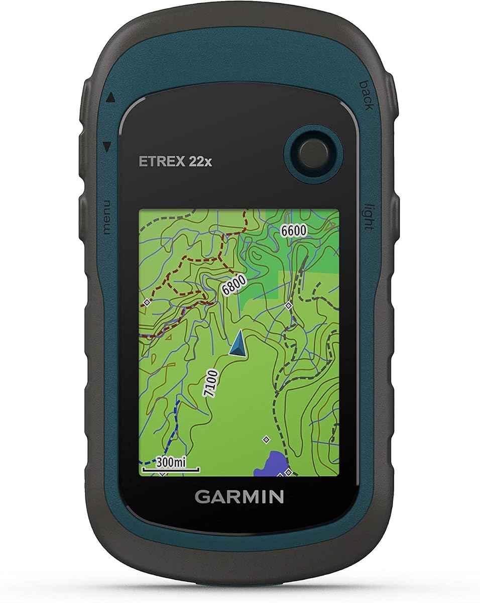
The Garmin eTrex 22x is a dependable choice for hikers who need a robust device without the high cost of premium models. It features a 2.2 inch sunlight-readable color display that ensures you can see your route clearly even on the brightest days on the Appalachian Trail.
We may earn a commission when you buy through this link, at no additional cost to you.
Preloaded with Topo Active maps, this unit provides detailed trail data right out of the box. The inclusion of both GPS and GLONASS satellite systems allows for more reliable tracking in challenging environments where a single satellite system might struggle to maintain a lock.
With 8 GB of internal memory and a micro SD card slot, you can store extensive map data for different sections of the trail or even other regions. The battery life supports up to 25 hours in GPS mode using standard AA batteries, which is sufficient for most day hikes or overnight trips.
This model is well-suited for traditional hikers who prefer physical buttons and simple menus. If you want a no-frills, tough device that gets you from point A to point B with accurate maps, the eTrex 22x is a solid and trustworthy option.
The display offers improved pixel resolution over older models, making it easier to distinguish trail paths and landmarks on the screen without straining your eyes during long hiking sessions.
Adding a micro SD card allows you to carry multiple map sets simultaneously, which is useful if you plan to explore beyond the Appalachian Trail or switch between different regional maps during your trip.
We may earn a commission when you buy through this link, at no additional cost to you.
The Garmin eTrex 32x builds on the foundation of the 22x by adding a 3-axis compass and a barometric altimeter. These additions provide more precise heading information and elevation data, which are crucial for navigating the varied terrain and elevation changes found along the Appalachian Trail.
We may earn a commission when you buy through this link, at no additional cost to you.
Like the 22x, it features a 2.2 inch sunlight-readable color display and supports both GPS and GLONASS systems for better tracking in difficult areas. The unit comes with 8 GB of internal memory, allowing you to store additional map data if you need more detail for specific hiking sections.
Battery life remains strong with up to 25 hours in GPS mode using two AA batteries. This endurance ensures you can rely on the device throughout a full day of hiking or overnight camping without worrying about running out of power before returning to a charging source.
This device is a good middle ground for hikers who need better navigation tools without upgrading to a more expensive GPSMAP series. If accurate elevation tracking and reliable compass readings are priorities for your route planning, the eTrex 32x delivers the necessary features effectively.
The 3-axis compass allows for accurate heading detection even when the device is tilted or not held perfectly level, which is common when hiking on uneven or steep mountain trails.
The barometric altimeter measures atmospheric pressure to determine your altitude, giving you a more accurate picture of your elevation gains and losses during your hike compared to standard GPS altitude.
We may earn a commission when you buy through this link, at no additional cost to you.
This Handheld GPS for Hiking offers a larger 3.2 inch screen than many standard GPS units, making it easier to view detailed maps without squinting. It supports multiple satellite systems including GPS, Galileo, and BeiDou, which aims to provide superior positional accuracy within 6 feet for precise trail tracking.
We may earn a commission when you buy through this link, at no additional cost to you.
The device is water-resistant with an IP66 rating, allowing you to hike confidently in various weather conditions. It features a rechargeable battery that can provide up to 36 hours of battery life on a full charge, and you can easily recharge it using a standard USB-C cable found in most packs.
Preloaded with USA Topo maps, this navigator is ready for outdoor hiking and camping right out of the box. The 32 GB of internal memory gives you plenty of space for map downloads and other data, ensuring you have the necessary information for your Appalachian Trail adventure.
While it lacks the brand legacy of Garmin, the feature set makes it an attractive option for budget-conscious hikers. If you want a larger screen and modern charging capabilities at a lower price point, this device provides a functional alternative for general navigation needs.
The 3.2 inch screen provides a wider view of the map, allowing you to see more terrain features and upcoming turns without needing to zoom in or out as frequently.
The USB-C rechargeable battery means you can use a single cable for both the device and your power bank, simplifying your charging setup while on the trail.
We may earn a commission when you buy through this link, at no additional cost to you.
While not a digital GPS, The Appalachian Trail book is an essential companion for anyone planning to hike the trail. It is the only illustrated book officially published with the Appalachian Trail Conservancy and includes a removable full-size copy of the official National Park Service map of the entire trail.
We may earn a commission when you buy through this link, at no additional cost to you.
The book features more than 300 spectacular contemporary images along with unpublished historical photos and documents. This visual guide helps you understand the beauty and significance of the route, inspiring your planning with essays on history and conservation that deepen your appreciation for the landscape.
Hikers can use the book to plan their route and understand the day-by-day hiking experience. The foreword by Bill Bryson and contributions from the ATC archives provide authoritative information that complements digital navigation tools, ensuring you are prepared for the cultural and physical journey ahead.
This resource is perfect for pre-trip preparation and keeping as a reference during your hike. If you want to deeply connect with the history and geography of the trail before you step on the path, this book is an invaluable tool that every hiker should consider.
The removable National Park Service map allows you to use it in the field for reference, giving you a detailed overview of the entire trail that digital maps might not capture in a single view.
Reading the history and significance of the trail in this book helps hikers appreciate the efforts of volunteers who built it, adding depth to their experience of walking in their footsteps.
We may earn a commission when you buy through this link, at no additional cost to you.
The Garmin eTrex 20x features an upgraded 2.2 inch 65K color display that offers improved resolution for better map visibility. It includes a high-sensitivity WAAS-enabled GPS receiver with GLONASS support, which helps locate your position quickly and precisely even in heavy tree cover.
We may earn a commission when you buy through this link, at no additional cost to you.
With 3.7 GB of internal memory and a microSD card slot, you can load various map types including TOPO 24K for detailed topographic data. The device comes with a worldwide basemap with shaded relief, providing a useful reference layer for your outdoor adventures on the Appalachian Trail.
Its compact design makes it easy to carry in a pocket or pack without adding significant weight. The water-resistant rating ensures the device can withstand light rain and splashes, keeping your navigation tools functional during typical hiking weather conditions.
This model is ideal for hikers who want a simple, lightweight GPS without extra sensors like a compass or altimeter. If you need a reliable backup or primary device that focuses on core location tracking and basic mapping, the eTrex 20x is a practical choice.
The 65K color display renders terrain features with more depth and clarity than older monochrome screens, making it easier to identify trails and landmarks visually.
The microSD card slot allows you to install custom maps purchased from third-party providers, giving you flexibility to choose map styles that suit your specific hiking preferences.
We may earn a commission when you buy through this link, at no additional cost to you.
Grandma Gatewood's Walk tells the inspiring story of Emma Gatewood, the first person to walk the entire Appalachian Trail alone in 1955. Her journey at age sixty-seven demonstrates that age is not a barrier to achieving significant outdoor goals, offering a powerful message for modern hikers.
We may earn a commission when you buy through this link, at no additional cost to you.
The book draws from her diaries and trail journals, providing a genuine look at the challenges she faced. Her vocal criticism of poor trail conditions helped lead to improvements, showing how hikers can make a positive impact on the path they love through advocacy and persistence.
Reading her story can help prepare you mentally for the demands of a long-distance hike. It emphasizes resilience, simplicity, and the joy of walking, which are essential mindsets for completing the Appalachian Trail in one continuous journey or even shorter sections.
This book is a wonderful addition to your pre-hike reading list to boost motivation. If you want to learn from the experience of a true pioneer and find encouragement for your own adventure, this narrative provides the spirit needed to tackle the trail.
Emma Gatewood's determination to walk despite societal expectations shows that mental strength is just as important as physical training for long-distance hiking success.
Her story is intertwined with the trail's history, helping readers understand how the path has evolved and the human effort required to maintain it for future generations.
We may earn a commission when you buy through this link, at no additional cost to you.
This guide offers 101 spectacular hiking trails across six northeastern states including Maine, New Hampshire, and Vermont which border the Appalachian Trail. It serves as a great resource for training hikes or side trips you might take before or after your main trek on the trail.
We may earn a commission when you buy through this link, at no additional cost to you.
The book features 101 detailed maps and 140 stunning color photographs that help you visualize the terrain and understand the scale of different hikes. Expert guidance and professional photography make it easy to identify trails that match your fitness level and interests in the region.
While it does not focus solely on the Appalachian Trail, the regional insights are valuable for understanding the local landscape and conditions. The detailed descriptions help you plan your route and anticipate challenges such as steep climbs or rocky paths common in the northeast.
This resource is ideal for hikers who want to explore the broader region surrounding the trail. If you plan to spend time in the northeast and want to get accustomed to the terrain, these classic hikes provide the perfect preparation for your main adventure.
Hiking these regional trails allows you to test your gear and build endurance in a similar environment to the Appalachian Trail, reducing the risk of injury during your main journey.
Understanding the geography of the states near the trail helps you appreciate the broader ecosystem you are walking through and plan logistics like transportation and lodging more effectively.
We may earn a commission when you buy through this link, at no additional cost to you.
Selecting the right GPS involves considering battery life, map quality, durability, and connectivity to ensure you have a reliable tool for your Appalachian Trail journey.
Battery life is one of the most critical factors for any long-distance hike. Look for devices that offer at least 20 to 25 hours of continuous GPS use, or those that support replaceable AA batteries so you can swap them in the field. Some units offer expedition modes that extend life significantly at the cost of tracking frequency.
Prioritize models with long endurance to avoid carrying heavy power banks for every outing. Always check if the device uses standard batteries or requires proprietary charging cables that might be difficult to find if lost.
The display must be readable in bright sunlight since you will be outdoors all day. Color screens with high contrast and sufficient size help you view maps clearly without squinting. Larger screens also allow you to see more terrain details at once, which reduces the need for constant zooming.
Choose a screen that is bright enough to view in direct sunlight and large enough to be comfortable for long periods. Ensure the glass is durable enough to withstand accidental drops or scratches during rugged use.
Your GPS will face rain, mud, drops, and extreme temperatures so durability is essential. Look for devices with water resistance ratings like IPX7 or IP66 to ensure they can survive wet conditions. A rugged build with reinforced corners protects the device from accidental impacts on the trail.
Invest in a device built to withstand the elements rather than a fragile consumer gadget. This reliability ensures your navigation tool remains functional even when the weather turns poor or you encounter rough terrain.
Detailed topographic maps are necessary to identify trails, water sources, and elevation changes. Check if the device comes with preloaded maps or if you need to purchase them separately. The ability to add custom maps allows you to tailor the navigation to your specific route needs.
Ensure the maps cover the Appalachian Trail specifically and are up to date with current trail conditions. A GPS that supports routing and waypoints helps you plan your stops and stay on track throughout your hike.
Modern GPS devices often support multiple satellite systems like GPS, GLONASS, and Galileo. This multi-GNSS support improves accuracy and signal lock in challenging environments like deep valleys or dense forests where sky visibility is limited.
Look for models that advertise support for multiple satellite networks. The more systems you have access to, the better your chances of maintaining a precise location fix when the terrain makes navigation difficult.
Connectivity features like Bluetooth allow you to pair the GPS with your smartphone for updates and trip planning. Some devices also offer satellite communication capabilities which are vital for safety when you are out of cellular coverage.
Check if the device connects to apps for easy data management and sharing. If safety is a primary concern, consider a model that includes emergency messaging or two-way communication features.
A GPS should be intuitive to navigate so you do not spend too much time fiddling with menus on the trail. Physical buttons are often preferable to touchscreens in wet or cold conditions where gloves are necessary.
Test the interface before your trip to ensure you can quickly access key features like waypoints and maps. A simple and logical layout saves time and keeps your focus on the trail rather than the device.
Weight adds up on long hikes so the size of the GPS matters. A compact and lightweight device fits easily in your pocket or small pack without becoming a burden. Consider how you plan to carry the device during the hike.
If you prefer not to hold the device constantly, look for wearable options that clip to your belt or pack strap. Balancing functionality with weight ensures you can carry your navigation tool comfortably throughout the day.
Begin by fully charging your GPS unit or inserting fresh batteries before you start your hike. Ensure that the maps and software are updated to the latest version to reflect current trail conditions and route changes.
Learn how to create and view waypoints using your device's interface before you hit the trail. Practice entering a destination and reviewing your route so that you are familiar with the process when you need it on the mountain.
Protect your GPS from extreme conditions by storing it in a padded case or pocket when not in use. Avoid leaving it in direct sunlight or freezing temperatures for prolonged periods to preserve battery life and screen functionality.
While the Appalachian Trail is well marked with white blazes, a GPS provides valuable safety backup in case of getting lost or encountering dense fog. It helps you track progress and locate water sources or emergency exits when visibility is poor or trail markers are missing.
Devices that use AA batteries are often preferred for long hikes because you can carry spare batteries easily. Rechargeable batteries are convenient but may require a solar charger or power bank to sustain usage over several days on the trail.
Connect your device to the manufacturer's app or website via USB or Bluetooth to download the latest map updates. Some devices support wireless updates through Wi-Fi networks which simplifies the process before you head out into remote areas.
While smartphones can be used with offline maps, dedicated GPS units generally offer longer battery life and better durability. Phones may drain quickly with continuous GPS use and are less resistant to water and impacts in harsh outdoor environments.
Most Appalachian Trail maps require less than 1 GB of storage so even basic devices with 4 GB of internal memory are sufficient. Having extra space allows you to store additional topographic maps for side trails or different regions.
Many GPS units come with attachment points that fit on backpack straps or belt loops. Using a quick-release clip allows you to access the device easily without taking off your pack or digging through your pocket.
The Garmin GPSMAP 65s leads our list with its multi-band precision and bright display making it ideal for serious adventurers. For budget-conscious hikers the eTrex SE offers excellent battery life and multi-GNSS support at an affordable price point.
Consider your specific hiking style when choosing a device. If you need advanced features like a compass and altimeter look at the eTrex 32x while those who want hands-free options may prefer the Foretrex 401 wearable model.
Prices and availability change often so it is always wise to verify the current offers before finalizing your purchase. Select a tool that fits your comfort level and ensures you stay safe and oriented throughout your journey on the Appalachian Trail.